Bruce’s Brief for April 22-23 and CYC’s PSSR

Bruce’s Brief for April 22-23 and CYC’s PSSR
Wind Speed/Air Pressure at West Point

If only we were racing today…..but we are not, so we might as well deal with it. It’s just difficult to look out at the Sound and see 8-knots from the north with a temperature of 55⁰F and not dream about racing or cruising in those conditions. OK, the wind chill is still around 46⁰F so it’s not exactly summer-like yet. It does, however, give us some hope for July 5th…….

The surface chart for today, 21 April, shows us the inevitable for this upcoming weekend. We’ve got both rain and wind headed towards us for both days and well into next week. As we said last week, the long range weather has us as being wetter and cooler than normal and with the jet stream staying well south of us, it is going to stay that way. Don’t kill the messenger.

The surface chart for tomorrow, 22 April, shows a moderately healthy front aimed right at us. The timing of frontal passage is still very unclear. The coastal buffer zone (CBZ) will once again have an impact on timing however it won’t be as dramatic as last weekend where it totally blocked the front and sent it off to the northwest and away from here. The key will be for you to check barometric pressure trends along the coast and inland reporting stations. It’s already starting to drop today so it will happen. After that, check the wind directions and wind velocities around the Sound, including the Washington State ferries on the Bainbridge and Edmonds-Kingston runs. The pre-frontal breeze will be southeasterly, while if the pressure is rising and the wind is out of the southwest, that would be post-frontal. It could, however, be a mixed bag as the front interacts with the CBZ. As per usual, expect stronger breeze along the coast and in the eastern Straits and the San Juan Islands.

That doesn’t necessarily mean light air in the race area off of Shilshole. It could mean 15-20 knots from the SSW in the morning backing off around midday to 5-15-knots from the south and then filling back in from the SW at 15-20-knots around mid-afternoon before slowly backing off towards sunset.

Sunday looks lighter however as the front has passed expect a more consistent onshore flow to develop over the course of the day which could have the breeze build slowly into the 15-20-knot range from the SW over the central and south Sound. The convergence zone will start in the north Sound around Port Townsend as strong westerly fills from Race Rocks to the East. The CZ will slowly work its way south to Edmonds and north Seattle by the early evening on Sunday.

Tidal Current at West Point
Saturday
0754 Slack
1124 Max Flood .82
1418 Slack
1600 Max Ebb .3
1936 Slack

Sunday
0842 Slack
1212 Max Flood .96
1506 Slack
1648 Max Ebb .38
2106 Slack

I have also included the graph of current velocity over time as it shows a distinctly non-sinusoidal curve so be aware especially with the flood being stronger than the ebb in a predominately southerly breeze situation. A little unusual so watch the COG and SOG.

Have a great weekend but be prepared for just about anything!

Bruce’s Weather Brief for April 15-16

Yet another interesting week of weather in the Pacific Northwest will wrap up with what could be the nicest weekend so far this year, especially on Easter Sunday.

The race tracker shows the fleet making its way west at about 1315 to Ballenas Islands, with Kinetic in the lead doing 12.8 knots.

The racers up in Vancouver for the South Straits got started this morning in what will probably turn out to be a bit of a slow race as the pressure gradient is widening over the area. Tracker Link.

After all the rain yesterday, punctuated with squalls that brought some rain, hail, and wind, a high-pressure ridge is starting to build over the area. Having said that, when you look at the Langley Doppler Radar you will see some significant rain still headed our way this afternoon. However, once that blows through, there won’t be much more for the rest of the weekend.

The strange part, but then again it is spring in the Pacific Northwest so expect anything, will be that while it will be generally light wind over most of the area, expect some breeze in the Straits on Saturday which will come down the Sound later on Saturday. The strange part is that the central sound will have breeze while it remains light in the North, South, and Eastern Straits. By breeze, we could see 15-20 knots from the north pretty much all day on Sunday.

Langley Doppler April 14

As you can see from the 500MB charts, the jet stream is still well south of us which will keep temperatures lower than normal over the area and keep the door open for more rain to wander in over the course of the coming week.

Enjoy the weekend!

Ed. Note: Bruce pulled double duty this week, doing a special Brief for the South Straits racers and today’s look at the weather for the rest of us. We’ll have a wrap on South Straits as soon as we can pull it together and get some reports from our Canadian friends. 


Bruce’s Weather Brief for Southern Straits Race. Pleasant and Cold, but Finish before 1700.

Bruce’s Weather Brief for Southern Straits Race. Pleasant and Cold, but Finish before 1700.

The good news is that the forecast models are actually starting to converge and looks like this could be a relatively pleasant race. What a difference a week or a day can make! If we had started last Friday by Friday night some boats might have been seeking shelter from 40+ knots. If we had started this morning we would now be in 30+ knots at Sisters.

As you can see from the surface charts we do have another front that will be passing over us tomorrow probably sometime between 1200 and 1400 hrs. This is a cold front so make sure you are going to be prepared for some wet and cold especially tomorrow night. Not below freezing but with the wind chill you might be just above freezing, 5⁰-8⁰ C.

For the start, expect 5-15 knots from the SSE. As you work your way west out of English Bay and towards Halibut Bank the wind will begin to back very slightly and there will be some topographical compression resulting in higher wind speeds, not excessive but in the 12-18 knot range as you approach Sangster and Lasqueti Island. This will not last long as the gradient will begin to ease with frontal passage. Since the low-pressure system will be slowly curving away from the coast, the wind won’t completely evaporate but it will ease.

As the post-frontal wind comes down the Straits of Juan de Fuca it will curve up into the race course bringing slightly more wind to the west side of the course from Entrance Island south. North of Entrance, the mountains on Vancouver Island will begin to act a block keeping the breeze lighter near the Island. As the sun goes down know where your competitors and mark them with the handbearing compass to see who goes light where.

By 2200 to 0400 the breeze will tend to be from the SSW to SW in the 8-12 knot range. After around 0400 the breeze will drop consistently over the course down to the 5-10 knot range. After 0900 on Saturday, the breeze may drop even more, just in time to coincide with the building ebb near the finish line. YUK! By late the morning, we will start to see the breeze back to the SE and become a little spotty, especially from Halibut back to the finish. From about 1300 until about 1500 there will be a slight increase in the breeze but dropping again and then severely glassing off around 1700. Watch for the drainage breeze as you get closer to the finish.

Above all else try to finish before 1700 hrs on Saturday.

Editor’s Note: I’ll do a wrapup after the race, and would love to include some first-hand tales as I won’t be making the trip. Please send stories (long or short), snapshots and video links to kurt@meadowpointpub.com. Thanks! Good luck to all.

Bruce’s Brief: Storm Arcing away from the Coast, Small Boat PSSR and early South Straits Preview

Bruce’s Brief: Storm Arcing away from the Coast, Small Boat PSSR and early South Straits Preview

Certainly another interesting day out there and real fun for the weather geeks. As we said yesterday, this looked like just another winter weather storm, slightly elevated wind speeds but not as strong as the TV and radio folks would like to have us believe. As I write, the barometer here as well as in the Straits, and along the coast has started to go up which should indicate that this low-pressure system has started to arc away from the coast. In some cases rising rapidly which can be as bad as falling rapidly so we’ll watch those stations. The coastal buffer zone once again is helping to diminish wind speeds over the interior of Western Washington. Note the chart for Cape Elizabeth, which I will try to update before sending this out. I’ve also included the Langley Hill Doppler radar image because you can really see where the low-pressure is centered off our coast, especially if you run the “Reflectivity Loop.” It is clearly moving away from the coast.

As you can see from the surface charts everything is pointing towards a post frontal kind of weekend. I think given the option I probably wouldn’t head out this afternoon and instead just get the boat ready to go tomorrow, late morning. For the north, central, and south Sound expect 15-25 knots for south-southwesterly until mid to late afternoon. Before going anywhere, check the station reports on your VHF. Remember that the definition of heavy weather is the point at which you don’t feel comfortable with you, your crew or your vessel being able to handle the conditions. No harm in just spending a comfortable weekend at the dock getting caught up on boat chores or reading those owner’s manuals.

By Sunday things will ease off in the Sound however along the coast we’ll start to feel the effects of yet another low-pressure system headed our way. Check the 48 hour surface chart. More lows are out there however they are starting to weaken and as we saw this week, the closer they get to our coastal buffer zone, the weaker they become. There is some hope for better weather after all. The downside is in the 500MB charts which have the jet stream well to the south of us which is actually going to allow more moisture into California and keep us cooler and wetter than normal.

For PSSR at Shilshole, the boats and crews that like breezy conditions are going to love Saturday. The challenge will be where CYC sets the start-finish line. That’s because even though the conditions are post-frontal, in other words, a southwesterly flow over the Sound, you will still have a very localized southeasterly coming out of the Ship Canal. This challenge will be compounded by stronger shifts to the southwest as the day goes on and the breeze starts to ease. Very tactical and challenging racing for sure.

I had a request from my friend Peter Salusbury up in Vancouver to gaze deeply into the crystal ball to see what conditions we may have for the best long distance race in the Pacific Northwest, South Straits of Georgia which will be starting on Friday, the 14th of April. Needless to say, if it had started today it would have been quite a thrash but then again we’ve come to expect this of that race. While the 11 April chart continues to show what appears to be an unrelenting string of low-pressure systems out there, they are really starting to weaken, except for that monster 972MB low on the International Dateline. It, however, is not moving our way so at this point conditions are looking relatively benign. Doesn’t mean you can slack off in your safety preparation, however. I’ve included the Navy charts for Friday and Saturday next weekend. I’ll have a special South Straits forecast on Thursday with a weekend post on Friday.

Have a safe and fun weekend!

Winter is not Quite Done with Us Yet….

Winter is not Quite Done with Us Yet….

While the sales folks at the radio and TV stations want to scare us with dire forecasts, this looks to be just another strong winter storm that will thrash the coastal waters. As you can see from the surface charts our Coastal Buffer Zone will once again do a pretty good job of keeping the strongest breezes offshore and along the coast by driving that 973MB low-pressure system to the NNW when it starts to interact with the coast.

That’s not saying the winds will be light over the Sound. By tomorrow afternoon expect winds 25-30 knots with gusts to 40 over the central and south Sound. The San Juans and coastal waters could see 30-35 knots with gusts near 50. For the central and south Sound expect the breeze to start dropping by 1700 to 1800 hrs tomorrow afternoon. The breeze will last into the early morning hours of Saturday in the San Juans, Gulf Islands, and Coastal areas.

The real problem will be that with all the rain we’ve had this will be enough wind to bring down some more trees and cause some landslides as well as power outages.

If you’ve had the boat out recently it is probably a good idea to add the extra winter mooring lines and additional fenders sometime tomorrow morning.

We’ll have another update for you tomorrow around noon. (Ed. note, we’re all lucky Bruce is keeping tabs on this for us and keeping his head while many of those in the media may be losing theirs….)

Bruce’s Brief for March 25-26 and Three Tree Point Race

Bruce’s Brief for March 25-26 and Three Tree Point Race

It’s the last race of the Center Sound Series and only a week to go before the Sloop Tavern Blakely Rock Benefit Race. Not only is the weather warming up, so is the racing and so is the cruising. For the first time in a long time, there were boats headed across the Sound to Blake Island this morning. Those folks are the smart ones as they are testing their boats before they go on the longer cruises later this spring or summer. This will give them plenty of time to make arrangements with their boatyard, boat maintenance facility or sailmaker to get any problems taken care of before the late spring/summer rush puts you way down the list. Just a thought….

(Ed. Note: We’re trying something new to us, a forum! If you want to discuss Bruce’s brief, the race or the series, try going here. You’ll have to create a login in the sidebar at the right. Of course, keep it civil and productive. Also, please help spread the word about this weather brief and the forum.)

While we’ve had yet another fairly wet week, tomorrow actually looks fairly decent with minimal rain and a nice breeze for racing even though we are going south of Alki. However, don’t get all excited and break out the lawn chairs and BBQ quite yet. Be sure to look at the 28 March Surface Forecast Chart and note that fairly nasty 973MB Low-Pressure system in the mid-Pacific with the label Hurricane Force. Yes, it will slightly degrade as it comes across the Pacific however it’s on track to get to the Pacific Northwest by next weekend. We’ll be watching that one.

Tidal Current at Sewage Point, whoops, I mean West Point.

0918      Slack

1224      Max Flood            .85 knots

1512      Slack

1718      Max Ebb                 .43 knots

2006      Slack

Since the tides are fairly minimal and mostly favorable we’ll focus on the wind and the course. The front on today’s chart rolled through our area between 0600 and 0700 this morning and we are now in a post-frontal situation which will hold through Saturday and see the offshore wind go from due southerly now to southwesterly and then westerly tomorrow before backing to the south-southeast on Sunday. The good news is that when the wind finally does force its way down the Straits into Admiralty Inlet, we should be finished. Keep your fingers crossed. The models are currently in agreement that we should have consistently south-southwesterly breeze over the entire course. Look for 8 to 15 in the starting area, which should build as you go across Elliott Bay to 10 to 20 and then ease to 10 to 15 from Alki to Three Tree Point. You’ll be sailing primarily on starboard tack and remember that the shortest course is right down the east side of the Sound so start with the headsail in the starboard groove so you can take a short hitch to port, hoist the new jib, and then tack back to the favored starboard tack to drop the old headsail.

Once again, since you’ll be sailing through the slower boats in front of you, find the clear air and don’t spend time sailing in dirty air.

At Three Tree Point, give the Point plenty of clearance. If you go aground here, your friends will never let you forget it. You’ll want to have all your spin gear set up for a port pole, port tack hoist and get this done before you leave the dock so you can keep everyone hiking all the way to the mark.

The run back to the finish should be fairly straight forward with no need to gybe. As you sail up the Sound be sure to watch the boats in front to see if the breeze goes forward near the top end of Vashon and Blake Island before coming aft again north of Alki. Have a headsail tee’d up just in case. This is also a leg where a staysail will pay dividends so talk about that in the morning before you leave the dock. Also, once everything is set and working, send the navigator below to check the wind reports on the VHF to make sure the northerly isn’t coming down the Sound ahead of schedule.

On the run back after about 1400 hours look for the breeze to start to drop from 10-15 to 6-10 knots. It will pay to be an early finisher in your fleet.

Sunday look for a strong pre-frontal southeasterly to develop in the eastern Straits while the breeze will stay less than 10 knots over the central and south Sound and oh yeah, the rain will return on Sunday as well.

Be safe and have a great day on the water.

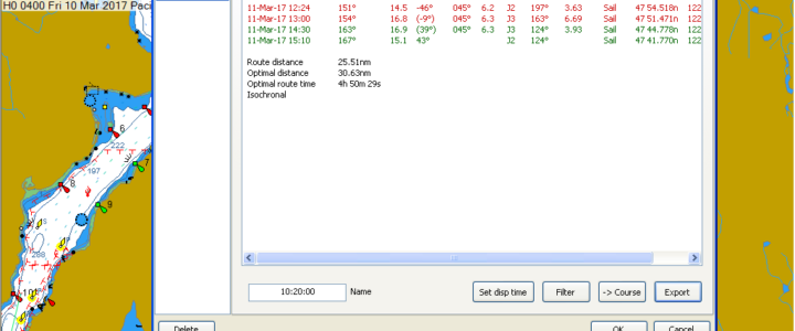
So how fast will Crossfire go around the course tomorrow? Based upon a course of 30 nm and Crossfire sailing 31.78 miles they should finish in 2 hrs 53 min and 40 secs. WOW!


Want More Bruce?

One of the great pleasures in creating sailish.com is working with Bruce Hedrick on the weather briefs. Obviously, there’s a wealth of knowledge there. Moreover, he genuinely loves sailing and racing and wants to share that with everyone.

But some of us want more Bruce. Maybe we’re thinking about that Vancouver Island circumnavigation or the big trek north to Glacier Bay or is it a good window to do a delivery down the coast to California? 

Bruce Hedrick

Fortunately, there’s a way to do it. Bruce’s advanced weather analysis and routing can be tailored to your timing and to your specific vessel. And while Bruce’s blood has a high percentage of baggywrinkle, much if not most of his routing is for motor yachts heading off on long voyages. Especially when it comes to going north of Puget Sound, using both weather and tidal analysis can extend the range of those precious tanks of diesel. Since most routing involves speaking with the skipper or navigator twice a day by sat phone, go, no-go decisions when it comes to open water crossings can be made with a very high degree of confidence. There’s no easier way to ruin a summer cruise than to get caught out in nasty weather.   

If you’re not familiar with Bruce’s qualifications, they’re a great mix of academic and practical. He and his brother Gregg raced on the family’s Columbia 50 in the 1960s. In the oh-so-active 1970s, his family campaigned the Chance 50 Warrior with great success. Along the way, he earned a Bachelor’s of Science from the University of Washington in Biological Oceanography and learned meteorology “to keep from getting kicked around on the race course.” 

Bruce spent nearly two decades as Managing Editor for Northwest Yachting Magazine, retiring in mid-2015, was the chairman of the Board of Trustees for the Northwest Marine Trade Association from 2013 until 2015 and currently serves on the Board.   

Over the years Bruce has navigated everything from The Perry 68 Icon to the Ranger 29 Ed. In 2015 he won class in TransPac as navigator aboard the Santa Cruz 50 Allure

Want more Bruce? Email him here.


Bruce’s St. Patrick’s Day Brief March 18-19 and a look at Gig Harbor Islands race

Bruce’s St. Patrick’s Day Brief March 18-19 and a look at Gig Harbor Islands race

For a while this week it looked like we would get two consecutive weekends of great sailing. Then again it is the Pacific Northwest. The models were converging for a while however by this morning the topography of the Northwest was wreaking havoc on consistency. But the weekend is here, as is the Gig Harbor YC Islands Race, so let’s take a look.

Tidal Current taken from the North end of the Narrows, Center Stream.

0948      Slack

1330      Max Ebb                 3.01 knots

1700      Slack

1924      Max Flood            2.61 knots

Since the current always flows north in Colvos Passage, the real key is to watch your COG and SOG and when you’re going north, find the axis of the current. When going south, avoid the axis when you can.

The reason why this weekend will be so challenging for forecasters is that once again a few miles difference in how the low interacts with the coast will make a big difference in the wind over the Sound. As you can see from the charts for today there are two lows off our coast, both with attached frontal systems and both moving to the northeast. The low currently off of northern California will have it’s front over us early tomorrow morning. If it tracks further offshore because of our coastal buffer zone then the post frontal onshore flow will travel further down the Sound creating a northerly scenario in Colvos. If it holds its current path the northerly will be delayed and Colvos will end up being a dead zone between the post frontal southwesterly breeze coming through the Chehalis Gap and the northerly filling down the Straits and then down Admiralty Inlet. If it passes closer to the coast and is slowed we could have a stronger onshore flow through the Chehalis Gap that would keep a southwesterly flow over the race course until late afternoon.

Regardless of which hand we are dealt it’s going to be an interesting race and because the GHYC always puts on a great event, especially before and after the race, it’s bound to be a lot of fun.

Almost regardless, the start will be downwind in a southwesterly of 5-12 knots. As you work your way up Colvos, the breeze will tend to back and probably back off to the 3-5 knot range. It’s as you get closer to the north end of Colvos that it could get very interesting as a convergent zone develops from Blake Island south to somewhere between View Park and Anderson Point. The transition may even have the breeze backing around to the east before becoming northeasterly and then northerly. Foredeck crews, navigators and trimmers are going to be busy but at least it will be raining.

When dealing with these transition zones it will be important for the foredeck crews to remember to keep putting the headsail up in the port groove because once you get back into the southwesterly in Colvos, it will start out light and then slowly build. You’ll have long starboard tacks and short port tacks as you keep working to the west side of Colvos to stay out of the ebb tide. That way if you have to do a change you’ll have more time to set it up on the starboard tack. In Colvos the puffs will be lifts on starboard tack so main trimmers and drivers will be working especially hard.

I had some fun last week with predicting elapsed times  (and the final tally here) for some of the boats so I’ll roll the dice again, however, I have a much lower confidence level for this forecast because of the changing parameters. This week I’ll use one of my favorite boats, the J-160 Jam which is currently predicted to go around the course in 4 hrs and 2 min. So we’ll see….. Have a great race.

Bruce’s Briefs for March 11-12 and Scatchet Head Race

Bruce’s Briefs for March 11-12 and Scatchet Head Race

Overall it appears that our cold winter is finally coming to an end. That’s the good news. It doesn’t, however, mean our wet winter is coming to an end. We are still just under five inches of rain ahead for the year and the way the 500MB picture is setting up, it doesn’t appear that this will be slowing down anytime soon.

Wind Speed/Air Pressure at West Point

The models for this weekend are coming together so nicely it’s almost scary. They almost never converge this closely at 24 hours out. Plus last night we had yet another example of how much fronts can shift as they approach the coast and how this can have a dramatic effect on the isobar orientation and the actual wind we get. The TV weather guys were warning of breeze to come in about 0100 hrs this morning with gusts to 50 mph. It actually showed up, at least in West Seattle, at around 2300 hours and the peak gusts were closer to 35 mph. In the overall scheme of forecasting, I would say that’s still fairly close. The front appeared to hit our coastal buffer zone and deflect up into Vancouver Island which had the effect of lessening the compression in the isobars and slightly reducing wind speed. We are now very much in a post-frontal situation which has the barometer rising rapidly, the wind coming around to the SW in the Sound staying at 20-25 knots and a very strong westerly coming down the Straits. This will ease as the day progresses.

Let’s look at the tidal currents for the race course first before we delve into the wind on the course. I use the currents at Foulweather Bluff from the Station ID PCT 1566 rather than 1611 as they are closer to time and direction at the Scatchet Head Buoy. The velocity of the current can vary quite a bit depending on how much water is coming down the Snohomish River and then flowing out of Possession Sound on the ebb. Not much rain, the current on the ebb will be about .5 to .75 the value at Foulweather Bluff. Lots of rain, like yesterday it will be closer to .75 to 1.0 the value.

Foulweather Bluff

0729      Max Ebb                 1.12 knots

1130      Slack

1324      Max Flood            .61 knots

1557      Slack

1929      Max Ebb                 1.3 knots

West Point

0848      Max Ebb                 .21 knots

1012      Slack

1254      Max Flood            .79 knots

1518      Slack

1724      Max Ebb                 .46 knots

With the amount of freshwater coming into the Sound you can expect the wind generated surface current to make the ebb start sooner, last longer and run at a slightly higher velocity.

As I mentioned above, when the models are this close this early, there is a tendency to develop a plan for how to sail the race and then not change the plan as actual conditions develop. This can get you into a lot of trouble especially in this race. It’s fine to develop the plan, just use all available data tomorrow morning before you go head out and then keep your head out of the boat to watch was actually happening with the weather.

Right now it very much looks like you’ll probably start on starboard and then immediately gybe to port to get west of the rhumb line and ride the slightly stronger ebb with slightly more wind to get north and then gybe to make a starboard approach to the mark. Remember that if you get up there in the ebb and the ebb is running at the mark, the current velocity at the mark can be much higher in the last ¼ mile setting you to the west, so put a bit in the bank to allow for the set. Also remember that if the barometer has started to fall and the wind is east of due south, hoist the jib in the starboard groove because you’ll be on a long port tack to get over to the west side of the Sound where the flood starts sooner and runs stronger all the way to Jefferson Head. Ideally, you won’t tack for the finish until you are confident you are laying the finish line. The reality is that as you come across the Sound on starboard tack, you’ll probably be headed as you get closer to Shilshole. If you end up below the finish line, hold starboard tack until you can lay the finish on port. Again, remember, that as you get closer to the Shilshole and the finish, the outfall from the Ship Canal will be stronger.

For a little fun this week, I ran projected times around the course based upon two different models (an idle mind is the devil’s playground) for Crossfire, a J-125, a J-109, a J-30 and a Cal 40 just because I have those polars. Remember, this is 24 hours out, I probably don’t have the correct sail inventories and these polars are probably not current.


Vessel                     Elapsed Time                        Miles Sailed       

Crossfire                 3h 01m 16s                           29.00

J-125                        3h 41m  38s                          29.51

J-109                        4h 25m 06s                          29.27

J-30                           4h 50m 49s                         29.42

Cal 40                      4h 50m  29s                          30.63


It will still be fun to see what happens.

For Sunday it looks like a light southerly in the south Sound, a 15-20 southerly in the central Sound and later in the day 20+ of south easterly in the north Sound and in the east end of the Straits.

Be safe and have a great time.

Ed. Note: We’re going to start up an e-newsletter, so sign up, for just weather or the whole enchilada. Yeah, it’s free. 


Bruce’s Blakely Rock Race Brief and Weekend Weather for the Pacific Northwest March 4-5

Bruce’s Blakely Rock Race Brief and Weekend Weather for the Pacific Northwest March 4-5

Yet another very interesting week for weather and for once, Seattle ends up with more snow than Minneapolis for the month of February. Speaking of snow, yes, it could happen tomorrow and this could send all the aerodynamic theorists on your boat into an absolute tizzy. You know who they are, the ones talking about attached or laminar flow, stalling and of course, the Kutta condition. When you sail in the snow you can finally see all of these very nicely and very visibly represented. Let the arm waving explanations begin!

Since there is little to no agreement in the models about what we’ll have for tomorrow, we’ll just start with the tides and there won’t be much of them.

West Point

0818      Slack

1000      Max ebb                .42 knots

1518      Slack

1835      Max flood             .89 knots


As the saying goes when it comes to racing in Puget Sound: You should have been here yesterday!

The chart of current conditions at West Point shows that this morning we had a gust to 35 knots and while the baro is still dropping, the wind is backing off. An unfortunate trend that will continue through tomorrow. The surface charts show the reason for this as we’re going to have frontal passage this afternoon and into the early evening. The chart for Saturday morning shows the front well into Eastern Washington leaving a large gap in the isobars for Puget Sound and an onshore flow of cool, ok COLD, unstable air.

Almost all the models show wind from the south in the 5-8 knot range for the start however by noon they start to widely diverge with the wind in some cases dropping into the less than 4-knot range and clocking to the southwest. Other models show it dropping to the 4-6 knot range and backing to the south-southeast. By 1400 hours one model has the breeze glassing off south of West Point and becoming light and variable over the rest of the course but starting to fill back in by 1800 hrs. Trust me, we’ll all be very wet and cold by that time and should be back at the Club for some well-deserved warming fluids.

While the tide may only be around .5 knots, that will still be enough to send you towards the east shore from the starting line. There will still be a very localized southeasterly from the starting area south to West Point. This will mean that you can get both port tack lifts and stay out of the tide. Once you get to West Point it will be time to hold port tack and beat feet to the west. This is where you’ll want to be very careful to find a lane of clear air because remember, the slow boats are starting first and as the fleet converges, the wind will get very chopped up. If you’re sailing low and slow and unable to get to target boat speed you’re probably sailing in dirty air. Don’t hesitate to take some short hitches to get back into clear air, you simply can’t afford to sail in dirt all the way across the Sound. Your tactician should be thinking two to four tacks ahead to keep you out of trouble.

There are still no points for hitting Blakely Rock even though people try that every year so know the limits. If this is the first race of the year for you, plan on a bear away set, pole to port and then take plenty of time to get set up for the gybe. There will tend to be more wind to the west so holding to the west of rhumb and staying in touch with your competition is probably the conservative way to play this leg.

While on this leg if you start getting dramatic puffs from the southwest, that is usually an indication that the breeze is going to drop and potentially die. If the breeze stays from the south and backs slightly to the south-southeast, sail in those puffs and stay on the favored gybe to the mark, sailing the long gybe first. This is also NOT going to be the Miller Time leg. Trimmers and that means everyone is going to have to constantly play the kite, raise and lower the pole, trim the main, and keep the boat at top speed all the time. Remember also that when you get a puff from ahead, don’t sail off immediately, trim for max speed and only after the boat has gotten up to speed do you try to work the boat down.

From the leeward mark to the finish, if it’s light and from the west-southwest, just keep the boat moving towards the finish, holding on starboard tack but staying in the clear air. Don’t let too many people accumulate in the cockpit and it’s not all bad to get folks below deck and on top of the keel. On the downwind leg, check the lay of the finish line so you know which end is favored. Remember that with all the rain, the ebb will last longer and in the vicinity of the finish line, it might be a little stronger because of the outfall from the Ship Canal so watch COG and SOG as you get close to Meadow Point.

Good luck, have a great race and don’t forget those daffodils for when you round Blakely Rock.

Ed. Note: A forecast like this wouldn’t have dampened Kelly O’Neill’s enthusiasm. In fact she’d light up the Sound! Daffodils, all.