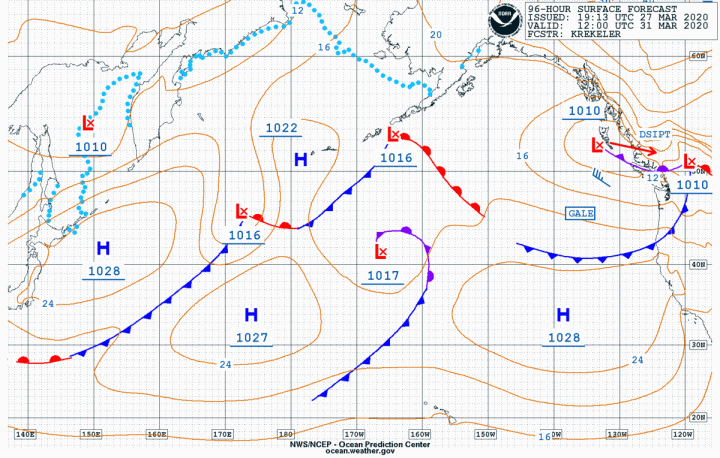
While March is supposed to go out like a lamb, this year will be the opposite with a weak front going through the area tomorrow which will bring southerly breezes for the Sound, Admiralty Inlet, Eastern Strait of JdF, and the San Juan Islands with the potential for Small Craft Advisories.
March 27 500MB
March 29 500MB
March 31 500 MB
March 31 Surface Forecast
After the front passes there
will be a brief post-frontal westerly in the Strait of JdF with strong
southerly breezes on the coast starting Sunday night. These will move inland
early Monday morning and then rapidly dissipate.
Satellite
Not a great weekend to be out on the water but better than being cooped up at the house. At least go down and check on the boat because better times are ahead.
Stay safe.
Ed. Note, looking forward to those better times. In the meantime everyone stay safe and help keep the rate of infection down. -KH
Bruce has raced and cruised the Pacific Northwest his entire life. He earned a Bachelor’s of Science from the University of Washington in Biological Oceanography and learned meteorology “to keep from getting kicked around on the race course.” Bruce spent nearly two decades as Associate Publisher for Northwest Yachting Magazine, retiring in mid-2015, and was the chairman of the board of trustees for the Northwest Marine Trade Association in 2014. (photo of Bruce driving Playstation is a bit dated, but cool)
For those of you who are racing tomorrow, especially at
Royal Vic and Bellingham, dress warmly, life jackets and safety harnesses for
sure, and if you’re not comfortable with the conditions, don’t go! It looks
like the Islands Race will have a nice breeze for the entire day with maybe as
much as 20-knots, while Bellingham and Victoria could see 30-40 knots of
northeasterly with gusts near 50! WOW! That’s a lot of wind.
Now (1600 hrs) up at the eastern end of the Straits of JdF we have a west-southwesterly breeze of 6 knots, which still gives a wind chill of 30-degrees, and the barometer is still falling. We can see snow up on the hills above Port Angeles and Sequim so the cold air is here but it is rain mixed with snow at sea level.
March 13 500MB
March 13 Surface Analysis
March 14 Surface Forecast
March 15 500MB
March 15 Surface Forecast
March 17 Surface Forecast
As you can see from the charts, we have a stationary frontal system that is slowly moving to the east. With the barometer still falling along the coast and here on the south side of the Straits this will keep the strong winds and very cold temperatures up north. It’s already 31 from the NE at Race Rocks so it’s coming.
So why will this northeasterly be so strong? Just look at the high-pressure system in the NE part of BC, it was at an ear-popping 1056mb this morning and it’s only going to weaken very slightly over the weekend. So with a pressure gradient difference of about 50mb, we are looking at some serious wind coming down the Fraser River Valley, blowing across the San Juan Islands and Bellingham, and then across the Straits of JdF. From there the breeze will be topographically forced down Admiralty Inlet and then down the Sound, slowly easing as it encounters landmasses.
This will mean a nice northerly in Colvos Passage that should last the entire day. In other words, a hard beat up the passage, hiking like crazy followed by a quick run back the finish and then into the Tides for well deserved hot-buttered rums, while maintaining that critical 6-foot social distance. You’ll get lots of tacking and gybing practice so that should help keep you warm. 😊
Bruce has raced and cruised the Pacific Northwest his entire life. He earned a Bachelor’s of Science from the University of Washington in Biological Oceanography and learned meteorology “to keep from getting kicked around on the race course.” Bruce spent nearly two decades as Associate Publisher for Northwest Yachting Magazine, retiring in mid-2015, and was the chairman of the board of trustees for the Northwest Marine Trade Association in 2014. (photo of Bruce driving Playstation is a bit dated, but cool)
Ed. Note: Please share with anyone who might be affected. The area mentioned in the headline above will be subject to a real blast of Fraser River outflow starting tomorrow afternoon and extending through Saturday. The reason for those is one very large high-pressure system positioned over eastern BC which has been as high as 1055mb which is really high. The charts show the compression of the isobars immediately to the NE of Bellingham and Vancouver. This will bring strong NE breeze, 30-50 knots with higher gusts, to the area as well as significantly cooler temperatures.
March 14 Surface Forecast
March 14 0500 Surface Forecast
March 13 1700 Surface Forecast
March 13 Surface Forecast
With the low that you see offshore this will also bring Strait Effect snow to the US side of the Straits from Port Townsend to Sekiu especially in the Olympics.
Add the extra mooring lines and fenders for this one.
Bruce has raced and cruised the Pacific Northwest his entire life. He earned a Bachelor’s of Science from the University of Washington in Biological Oceanography and learned meteorology “to keep from getting kicked around on the race course.” Bruce spent nearly two decades as Associate Publisher for Northwest Yachting Magazine, retiring in mid-2015, and was the chairman of the board of trustees for the Northwest Marine Trade Association in 2014. (photo of Bruce driving Playstation is a bit dated, but cool)
It’s our
favorite time of the year: the start of CYC’s Center Sound Series! The good
news is the front went through this morning and all that remains is some
scattered showers. The bad news is that models are not in agreement about what
will happen tomorrow. What we are in agreement on is that it will be good to
get out racing again.
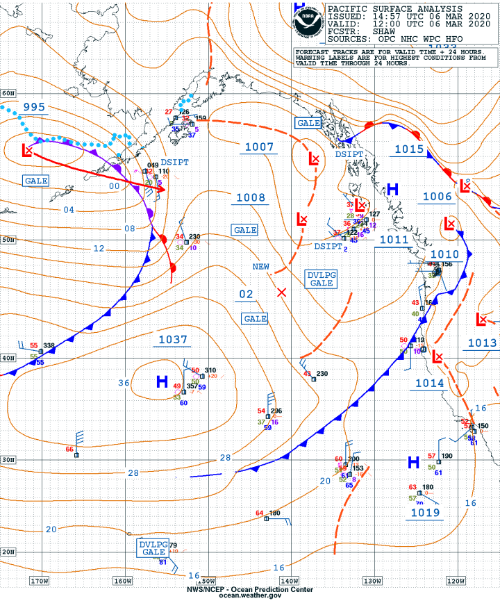
March 6 500MB
March 6 Surface Analysis
March 7 Surface Forecast
March 8 Surface Forecast
March 9 Surface Forecast
March 10 Surface Forecast
We have generally light conditions over the central Sound today and the surface charts confirm that the pressure gradient will continue to ease over the weekend even with a weak trough that is scheduled to move through the area tomorrow. As that passes, a weak ridge of high pressure will build tomorrow afternoon and bring a weak NW breeze to the central Sound. Some models show a stronger southerly for tomorrow morning with a northerly maybe to 15 knots filling down the Sound mid-afternoon. Not so sure about that. Generally speaking, it looks light but we’ll see when we power out of Shilshole tomorrow morning and then expect anything!
The other
good news is that tides are very weak.
Currents at West Point
0830 Slack
1154 Max
flood .61
knts
1442 Slack
1612 Max
ebb .31
knts
The places to watch for current will be at the entrance to Ship Canal and on the south side of West Point where the ebb from the Duwamish will be flowing in a northwesterly direction.
As far as tactics go, get a clear air start and don’t get
to close to the beach north of West Point. You’ll also want to watch COG and
SOG as you tack out on port tack. The strongest flood will be just offshore
from West Point so if you’re laying that buoy just hold port and beat feet to
the west because the wind will tend to shift from southerly to southwesterly
the closer you get to Bainbridge but again don’t get too close to the beach and
remember the reef off of Wing Point. Staying out a bit will keep you in what
flood there is and after Wing Point, stay out to stay in better breeze.
Remember also that the flood flows into Eagle Harbor even as far south as the
piling marker.
Set up for a port pole set at the Rock and then hold port until you can gybe out near R 2 at the entrance to Eagle Harbor then work out. Remember also that if a northwesterly is coming down the Sound, the SSW breeze will shift to SW and then to WSW so you may hold port all the way north. If the wind is shifting that way, make sure the headsail is ready to go back up. As mentioned above, there is no agreement about when this shift might come in, so be sure to keep your head out of the boat and watch the curb feelers out in front of you to anticipate the shift.
If the northwesterly has come in then it may be a gybe set at the top mark followed by gybes to get to the finish and stay in breeze.
One model has Crossfire
and Sonic around the course in a
little over five hours with the J-35’s taking about 10.5 hours.
Regardless, bring your warm foulies and wear your sunblock! Have a great time and we’ll see you out there!
Ed. Note: Please send race anecdotes, observations and tales to me and I’ll try to work them into post-race coverage. Thanks! KH
Bruce has raced and cruised the Pacific Northwest his entire life. He earned a Bachelor’s of Science from the University of Washington in Biological Oceanography and learned meteorology “to keep from getting kicked around on the race course.” Bruce spent nearly two decades as Associate Publisher for Northwest Yachting Magazine, retiring in mid-2015, and was the chairman of the board of trustees for the Northwest Marine Trade Association in 2014. (photo of Bruce driving Playstation is a bit dated, but cool)
This is the perfect weekend for the Safety at Sea program on Bainbridge Island. If you haven’t signed up, it’s too late as this great program is completely sold out! A huge well-done to Margaret Pommert for putting this all together.
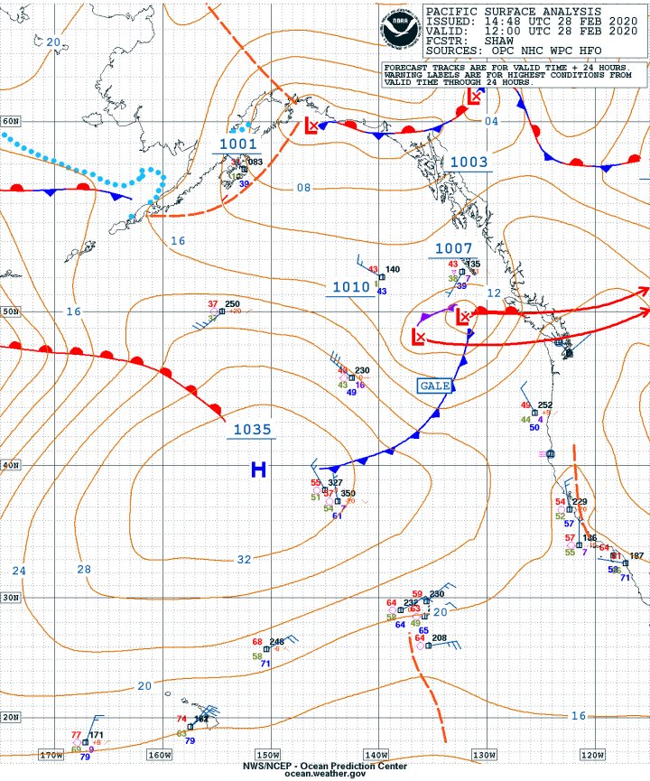
As you can see from today’s chart, we have a couple of weak
low-pressure systems off the coast with an attached cold front that will move
through the area late this afternoon and into the evening. It’s moving very
quickly so the high wind speeds (25-30 knots)
over the central Sound will not last long. After frontal passage, a
strong onshore flow will come down the Straits and gradually work its way down
the Sound late Saturday. The onshore gradient
will ease late Saturday and into Sunday. Today’s prints from Langley Hill
Doppler and the Goes Sat Pic clearly show this front.
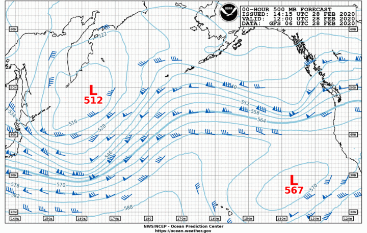
February 28 500MB
February 28 Surface Analysis
March 1 500MB
March 1 Surface Forecast
March 2 Surface Forecast
March 3 Surface Forecast
The other interesting transition to watch will be the
development of a fairly strong (1043mb) high-pressure system off the California
coast. It’s interesting in that as this high builds it will have the effect of
modifying the upper airflow from zonal to meridional. Note that on today’s upper air chart there is
no high showing below the jet stream and yet by Sunday it is quite pronounced.
This will allow another series of fronts to come into the area by late Monday
and into Tuesday with more arriving by week’s end. This is all good as we still
need snow in the mountains to build the snowpack.
Next week is the start of CYC’s Center Sound Series so we’ll have a more detailed forecast for the race. In the meanwhile, Saturday might be a good time to do a bit of heavy weather sailing just to clean out the cobwebs, remember how to reef, and check the leads for the #3 and #4. Just make sure everyone has all their safety gear, jacklines are run and remember what the definition of heavy weather sailing is: It’s the point at which you no longer feel comfortable with your boat or your crew being able to handle conditions. In that case, have a crew meeting and go over all the safety gear and safety procedures at the dock.
Bruce has raced and cruised the Pacific Northwest his entire life. He earned a Bachelor’s of Science from the University of Washington in Biological Oceanography and learned meteorology “to keep from getting kicked around on the race course.” Bruce spent nearly two decades as Associate Publisher for Northwest Yachting Magazine, retiring in mid-2015, and was the chairman of the board of trustees for the Northwest Marine Trade Association in 2014. (photo of Bruce driving Playstation is a bit dated, but cool)
Ed. Note: Due to technical difficulties we were unable to post this until now (Saturday night). KH
You’d have to say that it was a pretty nice week in the Pacific NW and
that will all change this weekend. This will start as weak onshore flow will
begin today to be followed by a weak frontal system tonight and into Saturday.
This will keep the pressure gradient weak and result in light wind over the
Salish Sea for most of Saturday.
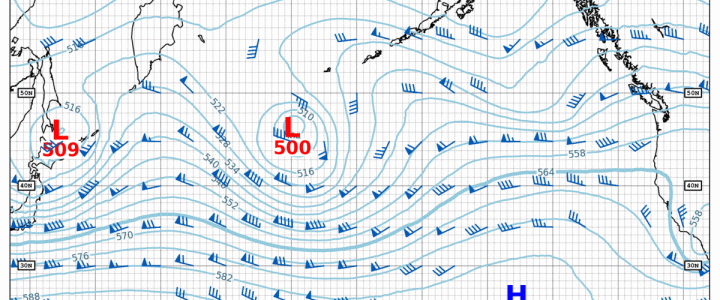
Feb 21 500MB
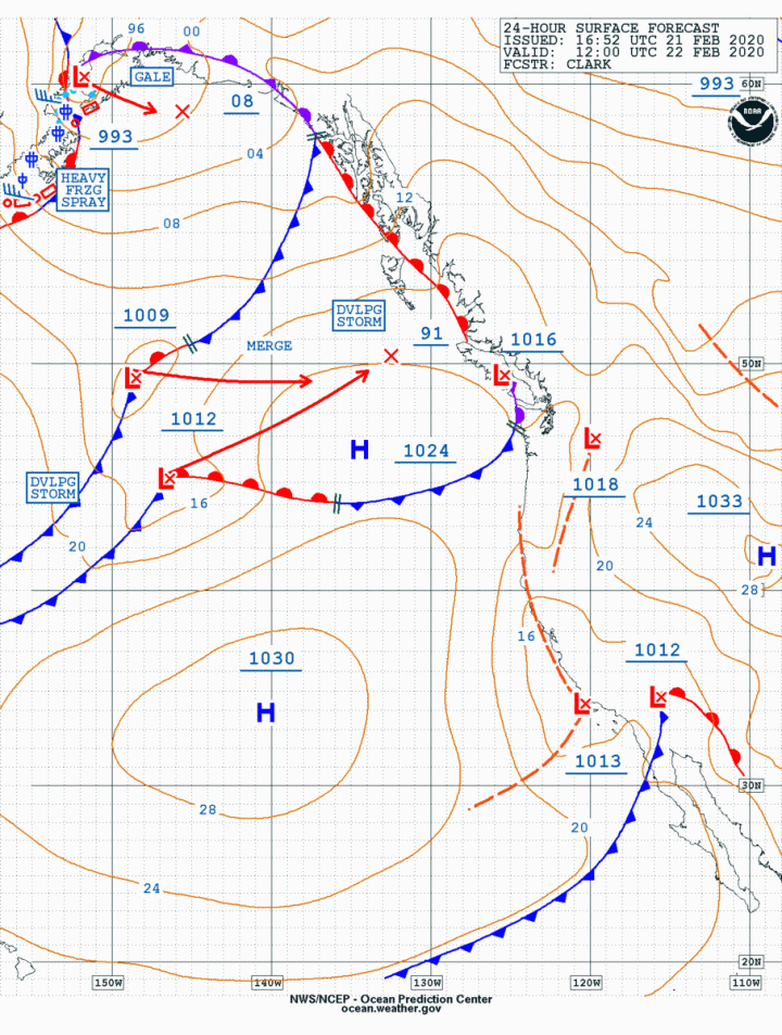
Feb 21 Surfae Analysis
Feb 22 Surface Forecast
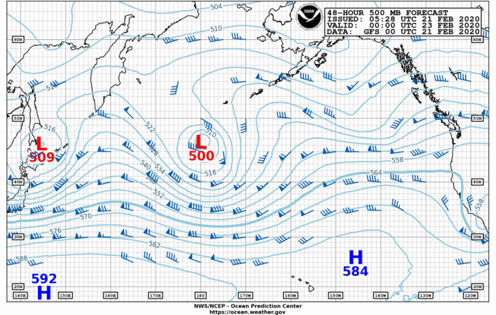
Feb 23 500 MB
Feb 23 Surface Forecast
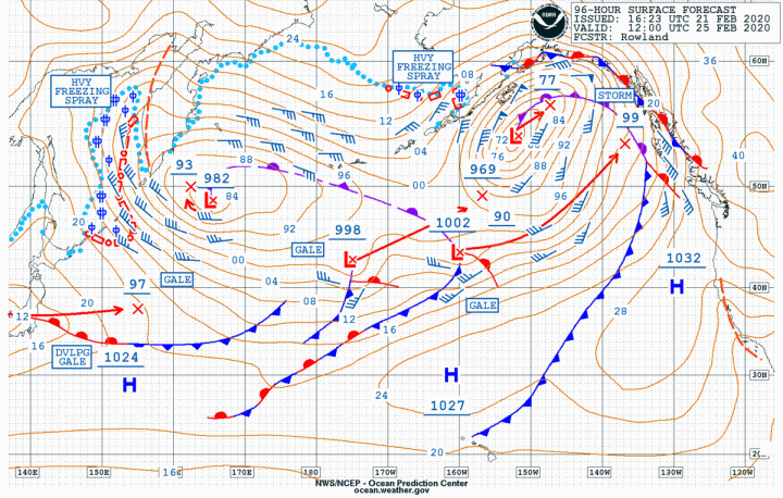
Feb 25 Surface Forecast
Sunday will be a completely different story as a much stronger front
will come through the area. Plenty of breeze over the area and with frontal
passage a strong onshore flow will develop in the Strait of JdF. This onshore
flow will begin to ease on Monday.
Today’s
charts show quite a different picture from last week where we had a strong high
pressure(1041mb)off of California. That has weakened to 1030mb and shifted
slightly to the west. The 500mb charts show a strong zonal flow over the
Pacific which will continue to bring storm systems right into the Pacific NW.
The
other feature to note is the remains of a cut-off low-pressure system off
California which will bring rain into LA and some snow into the Sierra
Nevada’s. All of which is needed.
Bruce has raced and cruised the Pacific Northwest his entire life. He earned a Bachelor’s of Science from the University of Washington in Biological Oceanography and learned meteorology “to keep from getting kicked around on the race course.” Bruce spent nearly two decades as Associate Publisher for Northwest Yachting Magazine, retiring in mid-2015, and was the chairman of the board of trustees for the Northwest Marine Trade Association in 2014. (photo of Bruce driving Playstation is a bit dated, but cool)
WOW! A Toliva Shoal Race with breeze! Don’t underestimate this as breeze could be up to 30 in the gusts. You really need to pre-plan the race before you leave the dock in Olympia so that you have a plan for every leg including a compass course for every leg so that if there is another heavy squall, you know which way to go. Make sure the jacklines are run and everyone is fully harnessed and safety-minded. Run the reef lines and have a discussion about the order in which a reef is put in. The other thing to plan for is the downwind start, probably on starboard so think about which headsail you’ll need for the leg from Johnson Pt to Mark #3 at the Nisqually Delta and use that in the starting area but get it set in the port groove so if you do have to change you can do an inside set, followed by short tack to port, then tack back to starboard for the final to Mark #3.
Feb 14 Surface Analysis
Feb 15 Surface Forecast
Feb 16 500MB
Feb 16 Surface Forecast
Feb 17 Surface Forecast
Feb 18 Surface Forecast
After that it’s another spinnaker set for the run-up to Toliva. The beat back will be the usual but as the front has passed, the baro will start to rise and there may be a brief drop in the breeze as it clocks to SW and then to the west. The other key will be the beat from Dofflemyer back to the finish where you will want to work the west shore so you are inside of the lifting puffs while on starboard. As you beat south as soon as you can’t lay the finish, tack back to the west and get back into the sw breeze.
The charts for today tell the story, especially with the new satellite picture. You can see the front slow as it interacts with the coastal buffer zone, it won’t weaken the front much which means breeze through Sunday when high pressure will rebuild over the area Monday and Tuesday.
Good luck, have a safe and quick race.
Duwamish Head Race, A Look Back
We didn’t get a race report out for the Duwamish Head Race, but it was a great second race in the South Sound Series. Here are the results and some of Jan Anderson’s photos, you know, to get you primed for this weekend.
Crossfire’s Track for Duwamish Head 2020
There was a man-overboard incident aboard Miss Mayhem. We’re expecting a sea-boots on the deck incident report in the near future and some observations from Jan Anderson’s photo boat Once again, Jan and Skip were on hand to help out. -Kurt Hoehne
Bruce has raced and cruised the Pacific Northwest his entire life. He earned a Bachelor’s of Science from the University of Washington in Biological Oceanography and learned meteorology “to keep from getting kicked around on the race course.” Bruce spent nearly two decades as Associate Publisher for Northwest Yachting Magazine, retiring in mid-2015, and was the chairman of the board of trustees for the Northwest Marine Trade Association in 2014. (photo of Bruce driving Playstation is a bit dated, but cool)
As we said last week, yes, the rain will end and now we have
a pretty good idea as to when that will happen and it’s looking like Sunday is
a pretty good bet! In the meanwhile we still have yet another quick hitter
coming through tonight and lasting into Saturday. The other impressive feature
this weekend will be the seas in the coastal waters which will build to
20-25-feet. This will make the bars at the river mouths pretty exciting places
and probably not anywhere you want to be especially on an ebb tide.
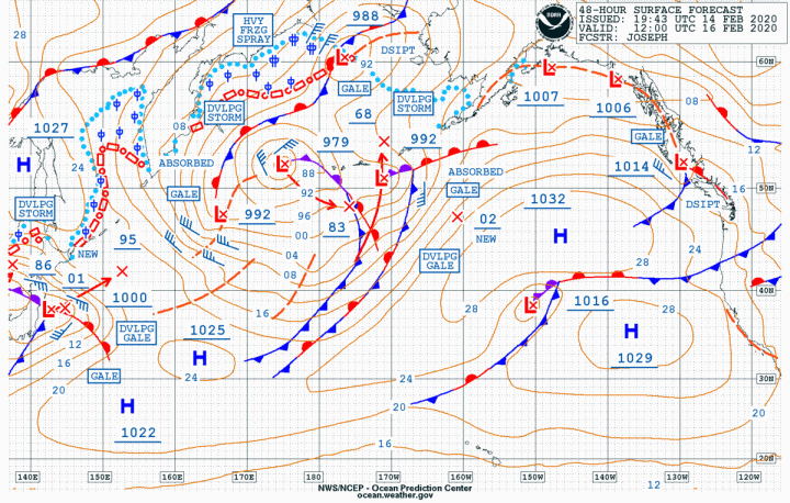
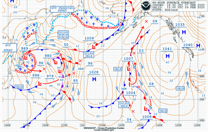
Today’s surface analysis chart shows a stalled front over the Pacific NW with a rapidly moving low coming right over us tomorrow. The center of the low will cover almost 700 miles in 24-hours which is good because that means it won’t have the opportunity to drop a bunch of rain on us as it moves rapidly to the east and high pressure builds not only in BC but in the Pacific off of the West Coast. By Sunday we’ll have a very strong (1041MB) high right off of our coast as well as two secondary high-pressure systems in BC that are not wimps. These will keep the next frontal systems at bay until late Tuesday and early Wednesday when another weak cold front will pass over the area.
Feb 7 500MB
Feb 7 Surface Analysis
Feb 8 Surface Forecast
Feb 9 500 MB
Feb 9 Surface Forecast
Feb 11 500MB
Feb 11 Surface Forecast
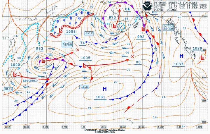
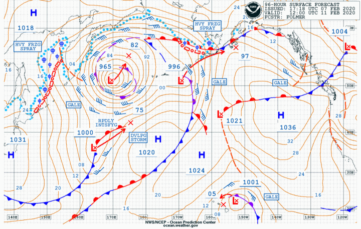
The other interesting feature of note in the 96-hr, 11 Feb surface chart is that the high has now weakened to 1036mb and is no longer as round as it used to be which means it will be pushed around by the next series of fronts that will be passing over it.
Feb 7
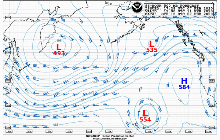
Another interesting feature on the 96-hr forecast chart is that low-pressure system lurking to the east of the Hawaiian Islands and moving towards the north end of that chain. I only point this out because, for the last two years in a row when this has occurred and been associated with an upper-level cutoff low-pressure system, Kauai has been pounded with extremely heavy rainfall resulting in catastrophic flooding in the Hanalei Valley. Take a look at the 500mb charts. The only difference has been that the two previous events occurred in April and this foretold an early move to the north by the jet stream which in turn brought a very early spring to the Pacific Northwest. We’ll see.
For the inland waters of Salish Sea, we can expect a nice
onshore, post-frontal northerly breeze for the north and central Sound for
Saturday. As this shifts to an offshore flow on Sunday, this will bring light
air to our waters but at least it will also bring some sunshine.
Enjoy the weekend and get ready for Toliva Shoal next
weekend.
Bruce has raced and cruised the Pacific Northwest his entire life. He earned a Bachelor’s of Science from the University of Washington in Biological Oceanography and learned meteorology “to keep from getting kicked around on the race course.” Bruce spent nearly two decades as Associate Publisher for Northwest Yachting Magazine, retiring in mid-2015, and was the chairman of the board of trustees for the Northwest Marine Trade Association in 2014. (photo of Bruce driving Playstation is a bit dated, but cool)
First of all, a BIG Thank You to all who took my weather class this Wednesday, to those who attended the seminar last night at the Boat Show and to those of you who stopped by the information booth at the Boat Show just to say hi. It’s always great to put faces to names and carry on a non-electronic conversation.
So to answer the above question, yes, of course, it will
stop raining just not any time soon. The good news is that the snowpack
continues to build in the Cascades and the Olympics and we are now 2.5 inches
of rain above the normal average for this date.
Today’s surface analysis shows that stalled warm front that is over us right now bringing rain and wind to the Salish Sea. This will be run over by a strong cold front tonight and into Saturday bringing even more rain and stronger wind to the area. When you combine the factors of supersaturated soil with high wind speeds you can probably expect some trees to come down as well as some power outages. If you can get away from work early today, it might not be a bad idea to give the mooring lines and fenders on the boat a quick check.
Jan 31 500MB
Jan 31 Surface Forecast
Feb 1 Surface Forecast
Feb 1 Surface Forecast 2
Feb 2 500MB
Feb 2 Surface Forecast
Feb 4 500MB
Feb 4 Surface Forecast
I think the really cool chart for today is the 48hr surface forecast chart which shows two very interesting surface features. The first being that monster low in the mid-Pacific which yesterday was at 948mb which is the deepest low we’ve seen this winter. It’s also not moving very far or very fast which means it is only going to slightly weaken as it moves towards North America. The second feature of note is that very summer-like high(1042mb) off of the north coast of California. This is very much a high we would love to see for any race to Hawaii. As we get out to around the 4th of Feb (96hr Forecast) the lows and attached frontal systems will continue to come into the Northwest and will degrade that high-pressure system and move it slightly to the southeast.
Now about that rain….This week marked an interesting
transition in the NOAA weather satellite constellation as they put GOES 14 into
“orbital storage” and brought GOES 17 online to cover the western region. You
can read the entire announcement below.
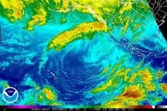
I mention this because today’s Satellite Picture is the new IR version
and provides a very graphic representation of the “atmospheric river” or
Pineapple Express coming from Hawaii and bringing a lot of moisture with it.
NOAA officials also announced GOES-14, which had been providing supplemental space weather instrument operations, will be powered off and placed in storage by January 31, 2020. GOES-16, perched in the GOES-East orbit, is sending more advanced space weather data to NOAA’s Space Weather Prediction Center. Additionally, GOES-17 is providing products in a developmental system for space weather. Having GOES-15 in storage allows GOES-17 to operate with sole coverage of the GOES-West domain, able to see the weather, including storms, fog and wildfires, at high-resolution in the western U.S., Alaska and Hawaii and much of the Pacific Ocean.GOES-15 and GOES-14 can be called back into service if either GOES-17 or GOES-16 experience issues.
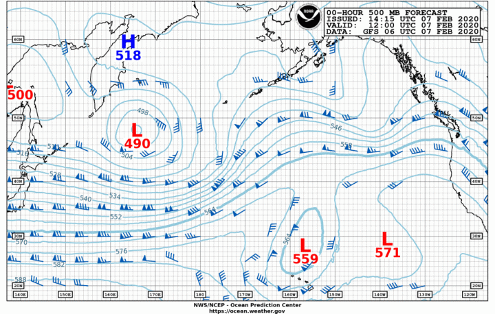
As always, if you’re going to look at the surface charts you might as well check the 500mb charts as well and then watch as the jet stream where it hits the Pacific Northwest moves generally south as it’s directed below the monster low and above that strong high. Then by the 4th of Feb, it becomes truly meridional in nature flowing due south along the coast.
All in all, it will be a very interesting week for the
weather.
Bruce has raced and cruised the Pacific Northwest his entire life. He earned a Bachelor’s of Science from the University of Washington in Biological Oceanography and learned meteorology “to keep from getting kicked around on the race course.” Bruce spent nearly two decades as Associate Publisher for Northwest Yachting Magazine, retiring in mid-2015, and was the chairman of the board of trustees for the Northwest Marine Trade Association in 2014. (photo of Bruce driving Playstation is a bit dated, but cool)
What a difference a couple of weeks can make. Our snowpack
for both the Cascades and Olympics is right around 90% of normal and we are .75
inches of rain ahead for the year. Now we’ll see if this moist pattern holds up
through the rest of the winter. Right now it certainly looks like a very wet
pattern for at least the next week. If I
had to pick a day this weekend to go to the In-The-Water-Show it would be
Saturday. Sunday is looking wet and breezy so the brokers will love that as
only the serious buyers come out in that stuff! Remember to always check the
Doppler Radar on the NWS Seattle website so you can see when the next rain will
be getting to us.
Jan 24 500MB
Jan 24 Surface Analysis
Jan. 25 Surface Forecast
Jan 26 500MB
Jan 26 Surface Forecast
Jan 28 Surface Forecast
Jan 28 500MB
The surface charts tell the story with one low-pressure system after another headed directly into the Pacific NW. The 48hr surface forecast chart shows an impressive 11 low-pressure systems in the Roser North Pacific LPS index, a seasonal high in terms of total lows. More importantly, the 500mb charts show an almost straight zonal flow across the Pacific. This will mean that the systems are fast-moving and that is confirmed by the length of the red arrows coming off the center of the lows, many of those show the center of the low covering 600 miles in 24 hours. Impressive.
Enjoy the weekend. I’ll be working at the Seattle Boat Show
Information Booth on the main floor at the Clink, today and tomorrow so if
you’re down there, stop by and say hello. I will also be teaching the all-day
weather class at the Boat Show University on Wednesday and a one-hour free weather
seminar on Thursday.
Bruce has raced and cruised the Pacific Northwest his entire life. He earned a Bachelor’s of Science from the University of Washington in Biological Oceanography and learned meteorology “to keep from getting kicked around on the race course.” Bruce spent nearly two decades as Associate Publisher for Northwest Yachting Magazine, retiring in mid-2015, and was the chairman of the board of trustees for the Northwest Marine Trade Association in 2014. (photo of Bruce driving Playstation is a bit dated, but cool)